Navigation

Louisiana Helping Louisiana coastal communities address weather and climate hazards.
Home

StormSmart LA

  • Home
    • About
      • Sitemap
      • Terms of Service
      • Contact Us
    • Community Rating System (CRS) Primer
      • CRS Credit Summary
    • No Adverse Impact (NAI)
      • NAI-level activities
    • Legal Introduction
      • Why You Should Manage Your Floodplains
      • The Four Types of Regulatory Takings
      • How NAI Can Help Your Community Avoid Lawsuits
      • Recent Relevant Legal Publications
  • Before the Storm
    • Identifying Hazards
      • Finding and Using Additional Hazard Information
      • Interpreting FIRMs and FIS Reports
      • Making Hazard Information Available and Accessible
      • Sharing Emergency Hazard Information
      • Understanding the Limitations of FIRMs and FIS reports
    • Planning
      • Creating a Community Master Plan
      • Creating a Multi-Hazard Mitigation Plan
      • Creating a Multi-Objective Management Plan
      • Creating Risk Mitigation Strategies
    • Regulations & Standards
      • Conducting Inspections of Lower-Area Enclosures
      • Considering Potential Future Conditions When Siting New Development
      • Creating Permanent No-Build Areas
      • Ensuring Local Regulations Allow Appropriate Development Techniques
      • Incorporating NFIP Requirements into Local Ordinances and Regulations
      • Keeping New Public Infrastructure Out of Hazard-Prone Areas
      • Passing Strict Zoning Ordinances and Regulations
      • Requiring Foundation/Building Certification
      • Using Freeboard to Elevate Structures above Predicted Floodwaters
    • Mitigation
      • Acquiring Existing Structures
      • Non-Structural Shore Protection
      • ONLY AS A LAST RESORT: Flood and Erosion Control Structures
      • Relocating Existing Structures
      • Retrofitting Existing Structures
    • Infrastructure
      • Improving Construction and Design of Critical Facilities
      • Insuring Public Buildings
      • Keeping Roads and Utilities Out of Damage-Prone Areas
      • Maintaining an Inventory of Hazard Risks for All Public Property
      • Protecting Critical Access Routes
      • Siting Critical Facilities Out of Harm’s Way
    • Emergency Services
      • Creating an Emergency Response Plan
      • Creating a Post-Disaster Recovery Plan
      • Improving Disaster Response Coordination
      • Planning for Outside Help
    • Training & Outreach
      • Sources for Outreach Materials
      • General Hazard Awareness
      • Hazard Training for Local Officials
  • After the Storm
    • Assessing Damage to Buildings
  • Funding
  • Handbook
  • StormSmart Connect
Return to Content

The Easiest Way to Find Louisiana Flood Maps

Posted on April 25, 2011

LA floodmaps 5
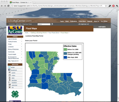
Click on your parish and get an interactive flood map. Wish all states had this resource. Have a look on the LSU Flood Maps site.

(Added to the Interpreting FIRMs and FIS Reports page.)

About Wesley Shaw

View all posts by Wesley Shaw →

hazard identification, Insurance, mapping

Trying to Drive Climate Change Adaptation? Focus on Social, not Environmental Vision
Survey: How Resilient is Your Community?