Navigation

Louisiana Helping Louisiana coastal communities address weather and climate hazards.
Home

StormSmart LA

  • Home
    • About
      • Sitemap
      • Terms of Service
      • Contact Us
    • Community Rating System (CRS) Primer
      • CRS Credit Summary
    • No Adverse Impact (NAI)
      • NAI-level activities
    • Legal Introduction
      • Why You Should Manage Your Floodplains
      • The Four Types of Regulatory Takings
      • How NAI Can Help Your Community Avoid Lawsuits
      • Recent Relevant Legal Publications
  • Before the Storm
    • Identifying Hazards
      • Finding and Using Additional Hazard Information
      • Interpreting FIRMs and FIS Reports
      • Making Hazard Information Available and Accessible
      • Sharing Emergency Hazard Information
      • Understanding the Limitations of FIRMs and FIS reports
    • Planning
      • Creating a Community Master Plan
      • Creating a Multi-Hazard Mitigation Plan
      • Creating a Multi-Objective Management Plan
      • Creating Risk Mitigation Strategies
    • Regulations & Standards
      • Conducting Inspections of Lower-Area Enclosures
      • Considering Potential Future Conditions When Siting New Development
      • Creating Permanent No-Build Areas
      • Ensuring Local Regulations Allow Appropriate Development Techniques
      • Incorporating NFIP Requirements into Local Ordinances and Regulations
      • Keeping New Public Infrastructure Out of Hazard-Prone Areas
      • Passing Strict Zoning Ordinances and Regulations
      • Requiring Foundation/Building Certification
      • Using Freeboard to Elevate Structures above Predicted Floodwaters
    • Mitigation
      • Acquiring Existing Structures
      • Non-Structural Shore Protection
      • ONLY AS A LAST RESORT: Flood and Erosion Control Structures
      • Relocating Existing Structures
      • Retrofitting Existing Structures
    • Infrastructure
      • Improving Construction and Design of Critical Facilities
      • Insuring Public Buildings
      • Keeping Roads and Utilities Out of Damage-Prone Areas
      • Maintaining an Inventory of Hazard Risks for All Public Property
      • Protecting Critical Access Routes
      • Siting Critical Facilities Out of Harm’s Way
    • Emergency Services
      • Creating an Emergency Response Plan
      • Creating a Post-Disaster Recovery Plan
      • Improving Disaster Response Coordination
      • Planning for Outside Help
    • Training & Outreach
      • Sources for Outreach Materials
      • General Hazard Awareness
      • Hazard Training for Local Officials
  • After the Storm
    • Assessing Damage to Buildings
  • Funding
  • Handbook
  • StormSmart Connect
Return to Content

Easiest Wind Speed Maps in the Gulf

Posted on May 4, 2011

LA Wind Speed  Elevation website
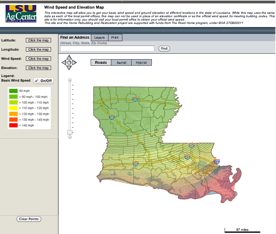
So you’ve figured out your flood risk with the LSU Ag Center’s flood map tool, but now you need an estimate of your wind risk. Why not check out their Wind Speed and Elevation Map? It just doesn’t get any easier. (Nice work, LSU).

(Added to our Finding and Using Additional Hazard Information page.)

About Wesley Shaw

View all posts by Wesley Shaw →

hazard identification, mapping, weather & climate

Survey: How Resilient is Your Community?
Not Mapped in the Flood Zone, Not at Storm Surge Risk? Not so Fast.